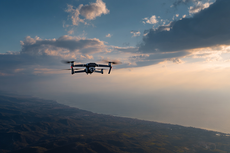
A significant portion of the microstock video market is built around aerial footage shot with drones, as well as video recordings of cities, landscapes, landmarks, and natural environments. These types of clips are in constant demand across advertising, editorial, documentary, and commercial projects, where geographic accuracy is often a decisive factor for buyers.
However, keywording this kind of content has always been one of the most time-consuming and error-prone tasks in a videographer’s workflow.
Manually identifying locations, spelling place names correctly, choosing the right level of geographic detail, and maintaining consistency across hundreds or thousands of clips can quickly become overwhelming. In many cases, the result is metadata that is approximate, incomplete, or simply wrong.
This is exactly the problem we wanted to solve with our latest feature on Photokeyworder.ai.
Introducing GPS-Based Keywording for Video Files
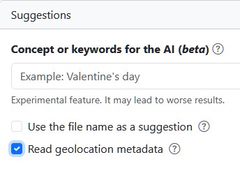
Starting today, under the “Concept of Keyword for the AI” section, you can enable the option “Read geolocation metadata.” This feature allows Photokeyworder to read GPS data embedded directly inside video files and use it as a reliable source for generating accurate, location-based keywords.
Instead of relying solely on visual analysis or manual input, the system uses the actual geographic coordinates recorded at the moment of shooting. This makes the keywording process not only faster, but also dramatically more precise.
Why This Matters for Drone and Location-Based Footage
Aerial videos and city or landscape footage are, by nature, strongly tied to their location. Buyers often search explicitly for cities, regions, countries, landmarks, or specific environments. When metadata is inaccurate, even high-quality footage can remain invisible.
Keywording this type of content manually can take a long time, and even experienced contributors may introduce small errors, inconsistencies, or vague descriptions. Over large portfolios, those small inaccuracies add up.
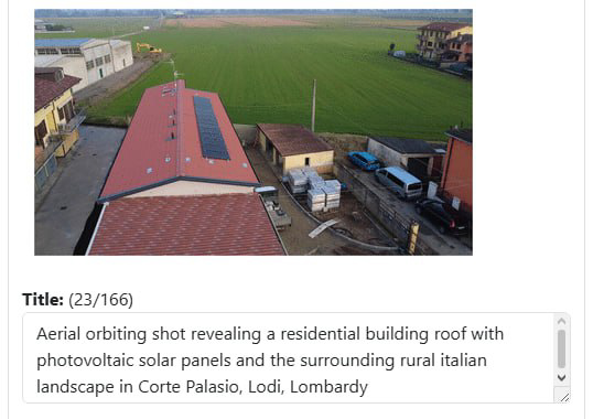
With Photokeyworder’s GPS-based system, the location tagging becomes deterministic. By reading the embedded GPS data, the software can identify the exact place where the video was recorded and generate precise geographic keywords accordingly. When the geolocation data is present and correctly recorded by the camera, the result is accurate by definition, with no room for interpretation errors.
Tested in Real-World Drone Workflows
We have extensively tested this feature using DJI drone video files, which represent one of the most common and widely used formats in aerial microstock production, and other devices too. The results have been excellent. Photokeyworder reads the GPS metadata correctly and translates it into clean, relevant, and precise location keywords.
This makes the feature particularly valuable for creators producing large volumes of drone footage, travel videos, and editorial city clips, where speed and accuracy are essential.
A Critical Requirement: Raw Video Files with GPS Data
IMPORTANT: For correct operation, videos must be uploaded in their raw, unedited form, and the recording device must support GPS metadata recording.
Most video editing software, such as Premiere Pro, DaVinci Resolve, Wondershare, and many others, removes embedded metadata during the rendering or export process. This includes GPS information. Once that data is stripped, it cannot be recovered, and even the most advanced keywording system cannot reconstruct the exact recording location.
For this reason, we strongly recommend keywording your videos before post-production. Upload the raw files to Photokeyworder, generate and save the CSV metadata, and only then proceed with editing and rendering. Keeping the original filenames unchanged ensures perfect alignment between your edited files and the previously generated CSV.
Designed for Serious Microstock Creators
This feature is built for contributors who work with large video libraries and understand how crucial metadata quality is for discoverability and sales. By leveraging GPS data directly from the source, Photokeyworder eliminates uncertainty and drastically reduces the time required to keyword complex, location-based footage.
When the camera records GPS data, the system can deliver perfect geographic tagging automatically, consistently, and without guesswork.
We believe this GPS-based video keywording feature represents a major step forward for aerial and location-focused microstock content. It is another example of our commitment to building tools that solve real problems in real production workflows.